What We Capture
Interiors
Grand halls to hidden corridors.
Façades
Detailed exterior architectural recording.
Architectural Details
Fine ornamental and structural features.
Landscapes
Surrounding environment and site context.
Condition
Recording current state for preservation.
Spatial Dimensions
Precise spatial measurements and scales.
Existing Features
Existing fixtures and unique assets.
Building Integrity
Complete structural and visual records.

Why It Matters
Preservation before deterioration occurs.
Accurate records for restoration work.
Remote access for consultants and researchers.
Planning future conservation work.
Insurance and disaster recovery reference.
Maintaining a permanent visual record.
Our Deliverables


Digital Twin
Virtual Tours
Archival Building Documentation
Comprehensive 3D virtual representations of physical assets for analysis and maintenance.
High-resolution photorealistic walkthroughs allowing remote exploration of historical sites.
Specialized high-fidelity photographic records documenting the current state of heritage assets.


Drone Scanning
Measured Drawings
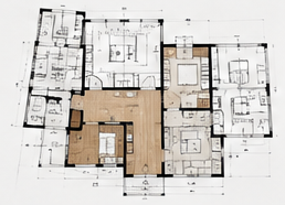
Floor Plans
UAV-based aerial photogrammetry and LiDAR for inaccessible roofs and large-scale site context.
CAD plans, sections, and elevations extracted from precise laser scan survey data.
Current updated floor plans for display, information or showcase.
Who It’s For
- Councils & Heritage Organisations
- Museums & Universities
- Architects & Conservation Specialists
- Property Owners
- Iwi & Community Organisations
Real-World Uses
- Restoration Planning
- Heritage Assessments
- Archival Documentation
- Condition Recording
- Educational Access
- Long-term Asset Management